LIVE🔴First Alert Weather Day: Tornado, severe thunderstorm watch in effect for most of Central Texas
The earlier severe thunderstorm watch has expired and has been replaced by another severe thunderstorm watch. Bosque, Hill, Limestone, Freestone, and Navarro Counties are under a severe thunderstorm watch until 4 PM. A TORNADO WATCH remains in effect for Lampasas, Coryell, McLennan, Bell, Falls, Milam, Robertson, and Leon County until 4 PM.(KWTX, SPC)
After non-severe storms moved through Central Texas Monday, we’re set for another round (at least!) of strong-to-severe thunderstorms. Tuesday is a First Alert Weather Day.
A TORNADO WATCH and severe thunderstorm watch are both in effect this morning
As of 8:30 AM, the Storm Prediction Center has placed nearly the entire area under some sort of severe weather watch. A tornado watch is in effect until 4 PM for Lampasas, Coryell, Bell, McLennan, Falls, Milam, Robertson, and Leon County.
A tornado watch is now in effect for Lampasas, Bell, Coryell, McLennan, Falls, Milam, Robertson, and Leon County until 4 PM. Meanwhile, a severe thunderstorm watch is in effect until 10 AM for San Saba, Mills, Hamilton, Bosque, and Hill County.(KWTX, SPC)
In addition, a severe thunderstorm watch is also in effect until 10 AM for San Saba, Mills, Hamilton, Bosque, and Hill County.
All severe hazards are in the forecast, but the tornado chance has increased
Severe thunderstorms are possible Tuesday potentially containing all severe weather hazards. Most of the area is under a level 2 severe weather threat, but a level 3 severe weather risk is in place east of I-35 primarily driven by an increase in the tornado potential. Tornadoes could be strong east of I-35 too!(KWTX, SPC)
Overall, all of Central Texas remains in at least a level 2 severe storm risk, but the Storm Prediction Center has raised the severe storm risk to a level 3 for Bell, Falls, Limestone, Freestone, Milam, Robertson, and Leon County. This increase in the risk outlook is primarily driven by an increase in the potential for tornadoes late this morning and early this afternoon.
Severe thunderstorms are possible Tuesday potentially containing all severe weather hazards. The tornado risk has INCREASED across the eastern half of the area with a level 3 tornado risk in place in Bell, Falls, Limestone, Freestone, Robertson, Leon, and Milam County. In addition to the higher tornado risk, we may see a strong tornado of EF-2 strength or higher.(KWTX, SPC)
The tornado risk is either at a level 2 or 3 with the level 3 risk also being confined in Bell, Falls, Limestone, Freestone, Milam, Robertson, and Leon County. This is the area that not only has the highest tornado potential, but this area also has the chance to see a strong tornado of EF-2 strength or higher. We won’t have enough energy in the atmosphere for a tornado stronger than EF-3 most likely, but even an EF-0 can cause some damage!
Severe thunderstorms are possible Tuesday potentially containing all severe weather hazards. The hail risk is at the level 2 of 5 category with the majority of the area under threat of significant severe weather. For hail, significant severe weather means the possibility of golf-ball size hail or larger.(KWTX, SPC)
Severe thunderstorms are possible Tuesday potentially containing all severe weather hazards. The wind gust threat is at a level 2 of 5 risk across the entire area.(KWTX, SPC)
The hail risk and the wind gust threat remain at a level 2 area wide today, but hail could potentially be larger than golf-ball size in the strongest storms. Winds will likely gust between 60 and 70 MPH.
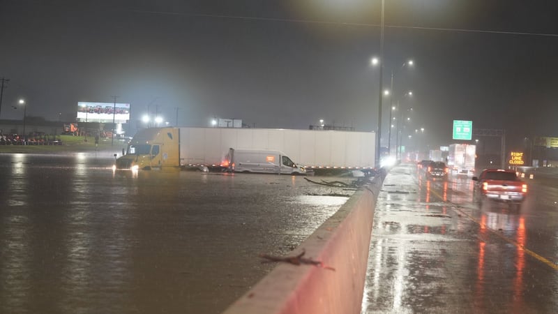
In addition to the severe storm risk, there’s also a level 2 flash flood risk as well. The flash flooding risk uses a 4 point scale. At the level 2 flash flood risk, that means there’s a 15% chance of seeing flash flooding around your neighborhood.
The Weather Prediction Center has placed most of Central Texas in a slight flash flooding risk, equating to a 15% chance for flash flooding.(KWTX, WPC)
A flood watch is in effect through the day Tuesday for Limestone, Freestone, Robertson, Leon, And Navarro Counties in Central Texas. In this area is where 1" to 3"+ of rain could fall during the day Tuesday leading to a heightened chance for flash flooding.(KWTX, WPC)
Severe storms arrive this morning and stretch into the early afternoon
Do NOT be caught off guard by the earlier arrival time of storms today compared to what you would normally expect! Although we normally see strong storms during the afternoon and early evening hours this time of year, the greatest severe storm risk is roughly from 8 AM to 6 PM! For many, severe storms will move in and out around or shortly after midday
A cluster of severe storms is set to blast through Central Texas today. Today's highest storm chances are in the morning hours, especially from 8 AM to 3 PM, with potentially some lingering storms east of I-35 through sunset. The main cluster of storms could produce very large hail, strong wind gusts, and a few tornadoes too. The tornado chances are highest east of I-35 with the main tornado risk opening around 10 AM today. In addition to the heavy rain, we're anticipating very heavy rain to fall, especially east of I-35, with 1" to 3"+ possible.(KWTX)
Today’s storm risk arrives from the west as a line of thunderstorms pushes into an increasingly unstable and warm airmass in place across Central Texas. Severe storms will likely start impacting the area after sunrise, likely between 7 AM and 8 AM west of Highway 281 with the cluster of storms marching toward I-35 by 10 AM.
A cluster of severe storms is set to blast through Central Texas today. Today's highest storm chances are in the morning hours, especially from 8 AM to 3 PM, with potentially some lingering storms east of I-35 through sunset. The main cluster of storms could produce very large hail, strong wind gusts, and a few tornadoes too. The tornado chances are highest east of I-35 with the main tornado risk opening around 10 AM today. In addition to the heavy rain, we're anticipating very heavy rain to fall, especially east of I-35, with 1" to 3"+ possible.(KWTX)
A cluster of severe storms is set to blast through Central Texas today. Today's highest storm chances are in the morning hours, especially from 8 AM to 3 PM, with potentially some lingering storms east of I-35 through sunset. The main cluster of storms could produce very large hail, strong wind gusts, and a few tornadoes too. The tornado chances are highest east of I-35 with the main tornado risk opening around 10 AM today. In addition to the heavy rain, we're anticipating very heavy rain to fall, especially east of I-35, with 1" to 3"+ possible.(KWTX)
A cluster of severe storms is set to blast through Central Texas today. Today's highest storm chances are in the morning hours, especially from 8 AM to 3 PM, with potentially some lingering storms east of I-35 through sunset. The main cluster of storms could produce very large hail, strong wind gusts, and a few tornadoes too. The tornado chances are highest east of I-35 with the main tornado risk opening around 10 AM today. In addition to the heavy rain, we're anticipating very heavy rain to fall, especially east of I-35, with 1" to 3"+ possible.(KWTX)
Although all severe weather hazards are possible with storms arriving before 10 AM, the tornado risk will increase after 10 AM near and especially east of I-35. Storms may also slow down a bit as they push east of I-35 which leads to the flash flooding threat.
A cluster of severe storms is set to blast through Central Texas today. Today's highest storm chances are in the morning hours, especially from 8 AM to 3 PM, with potentially some lingering storms east of I-35 through sunset. The main cluster of storms could produce very large hail, strong wind gusts, and a few tornadoes too. The tornado chances are highest east of I-35 with the main tornado risk opening around 10 AM today. In addition to the heavy rain, we're anticipating very heavy rain to fall, especially east of I-35, with 1" to 3"+ possible.(KWTX)
A cluster of severe storms is set to blast through Central Texas today. Today's highest storm chances are in the morning hours, especially from 8 AM to 3 PM, with potentially some lingering storms east of I-35 through sunset. The main cluster of storms could produce very large hail, strong wind gusts, and a few tornadoes too. The tornado chances are highest east of I-35 with the main tornado risk opening around 10 AM today. In addition to the heavy rain, we're anticipating very heavy rain to fall, especially east of I-35, with 1" to 3"+ possible.(KWTX)
A cluster of severe storms is set to blast through Central Texas today. Today's highest storm chances are in the morning hours, especially from 8 AM to 3 PM, with potentially some lingering storms east of I-35 through sunset. The main cluster of storms could produce very large hail, strong wind gusts, and a few tornadoes too. The tornado chances are highest east of I-35 with the main tornado risk opening around 10 AM today. In addition to the heavy rain, we're anticipating very heavy rain to fall, especially east of I-35, with 1" to 3"+ possible.(KWTX)
A cluster of severe storms is set to blast through Central Texas today. Today's highest storm chances are in the morning hours, especially from 8 AM to 3 PM, with potentially some lingering storms east of I-35 through sunset. The main cluster of storms could produce very large hail, strong wind gusts, and a few tornadoes too. The tornado chances are highest east of I-35 with the main tornado risk opening around 10 AM today. In addition to the heavy rain, we're anticipating very heavy rain to fall, especially east of I-35, with 1" to 3"+ possible.(KWTX)
A cluster of severe storms is set to blast through Central Texas today. Today's highest storm chances are in the morning hours, especially from 8 AM to 3 PM, with potentially some lingering storms east of I-35 through sunset. The main cluster of storms could produce very large hail, strong wind gusts, and a few tornadoes too. The tornado chances are highest east of I-35 with the main tornado risk opening around 10 AM today. In addition to the heavy rain, we're anticipating very heavy rain to fall, especially east of I-35, with 1" to 3"+ possible.(KWTX)
A cluster of severe storms is set to blast through Central Texas today. Today's highest storm chances are in the morning hours, especially from 8 AM to 3 PM, with potentially some lingering storms east of I-35 through sunset. The main cluster of storms could produce very large hail, strong wind gusts, and a few tornadoes too. The tornado chances are highest east of I-35 with the main tornado risk opening around 10 AM today. In addition to the heavy rain, we're anticipating very heavy rain to fall, especially east of I-35, with 1" to 3"+ possible.(KWTX)
A cluster of severe storms is set to blast through Central Texas today. Today's highest storm chances are in the morning hours, especially from 8 AM to 3 PM, with potentially some lingering storms east of I-35 through sunset. The main cluster of storms could produce very large hail, strong wind gusts, and a few tornadoes too. The tornado chances are highest east of I-35 with the main tornado risk opening around 10 AM today. In addition to the heavy rain, we're anticipating very heavy rain to fall, especially east of I-35, with 1" to 3"+ possible.(KWTX)
The main cluster of storms should depart the area by mid-afternoon, likely by 3 PM, but there’s a chance that another few pop-up strong storms may form mid-afternoon through the early evening hours east of I-35 not terribly far behind the main round of storms. The afternoon storm chances behind the main line are only near around 40%, but any storms that form could contain large hail and strong wind gusts.